The Best GPS for Hiking (Alternative Devices)
Is there really a best GPS for hiking? I’ve been using handheld GPS units for many years now and would argue that it’s nigh on impossible to choose one device that can be classed as the best. In fact, we should think of a GPS purely as a backup device. With that though in mind I’m going to look at some of the GPS options I’ve used on my travels.
My Choices of Hiking GPS
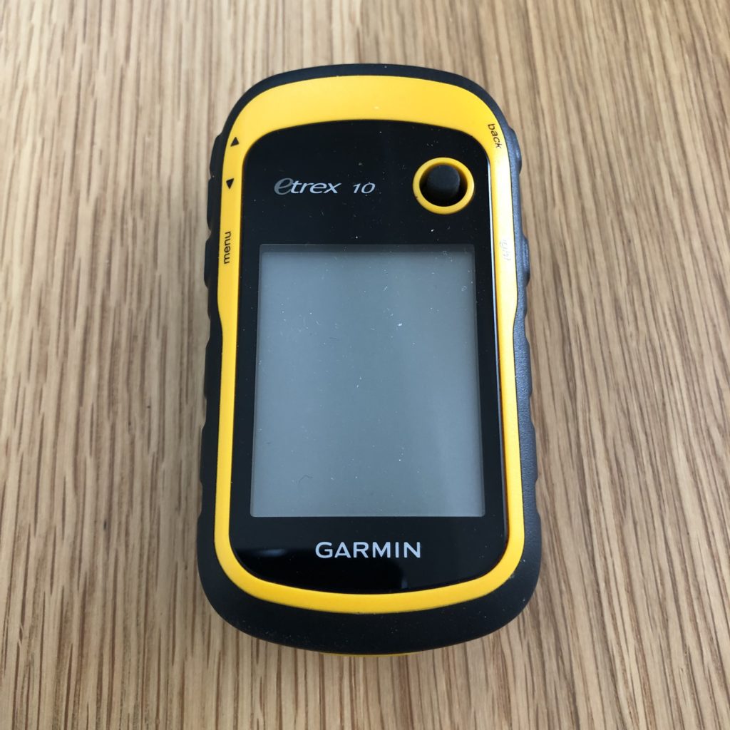
etrex 10 – simple and never failed
InReach – awesome, but a little pricey
Take a look around the web and you’ll find countless articles asking about the best GPS for hiking, or hill walking, or some of their physical activity. As some of you know I’m not a massive fan of having GPS purely for the sake of having GPS. I talk about the reasons why in my hillwalking essentials guide. Rather than regurgitate my thoughts you can read that post. For the sake of brevity, I firmly believe GPS should be a backup for outdoor activities. Nothing beats the ability to be able to understand and use a map and compass.
Here’s an example of what happens when the GPS fails. Last year I was on a big run, about 18 miles, over and around Wendover Hill. As I went through one of the hamlets on the hillside, I was stopped by a couple of hill walkers. One of them stopped me and asked if I could pinpoint his location on the map he was holding as his GPS batteries were flat and he was lost. Here ends this lesson.
Having a handheld GPS device as a backup is a great idea. The key is to ensure that the battery is always fully charged. Even on major expeditions – and access to only solar charging equipment – this is pretty easy. Most GPS devices are still powered by disposable batteries which are available pretty much everywhere, even in those tiny little village shops in the middle of nowhere.
I don’t want to attempt to give you a low down on all possible GPS options out as there are simply too many options, most of which are identical in functionality. Today I’m going to try something a little different. A quick search on the internet will show you huge number of review posts detailing the specifics of a manufacturer’s GPS model. Rather than do that I’d like to show you my best GPS for hiking options without going too deep into the various models and specifications.
Portable satnav devices, handheld GPS as it’s more commonly known, have been with us for many years. I remember years ago, back when I was serving in the army – the first GPS units were huge and heavy. Lugging one of those around is no fun partly because the Defence Evaluation and Research agency insisted on taking lightweight devices and encasing them in several kilos of metal. Apparently, the idea was to ruggedise them! I’m not convinced.
Garmin eTrex 10
As far as I’m concerned accuracy and simplicity are the most important aspects of a GPS. The ability to navigate is at the heart of every expedition. We really don’t need a device that shows you every possible trail or track on your route. Route selection should be done by the hiker, not by the device. Routes should be chosen via a map study.
What Makes the eTrex My Favourite?
The device fills 3 key requirements that I have for a GPS:
- it’s highly accurate
- it’s simple to use
- it’s incredibly lightweight
Open eTrex 10 GPS Quick Review
The eTrex 10 was released in 2011. The first unit was built with technology that gave users the ability to pinpoint their location to about 10 metres. In recent years the internals of the device have been upgraded and now allow navigation down to 1 metre.
Display on the eTrex 10 is simple, a monochrome LCD screen. Some basic information, such as spot heights, is available to navigators. What I really like about this device is that it removes all distracting information. This fact alone is a great way to emphasise map reading skills should be valued more than your ability to use a GPS.
Using the eTrex 10 is incredibly easy. Waypoints can be added manually, which is tedious. The GPS comes with a data cable that allows you to connect to a laptop and upload GPX files. GPX files or XML documents holding waypoint information. Many hiking and Hill walking routes around the UK and the world have been mapped and turned into GPX files.
The eTrex 10 GPS Physical Characteristics.
Weighing in at 140g, it’s incredibly light! The eTrex 10 has a massive battery life of 25 hours and is powered by 2 AA batteries. You can also use rechargeable batteries in the GPS. The GPS unit connects to both the American and Russian satellite systems which means you can find your location faster and more accurately.
Acquisition time – the time it takes for your GPS to lock onto orbiting satellites – is around 3 to 5 seconds. The eTrex 10 does a pretty good job of retaining previously used satellites in memory. That said, and from personal experience, I would always give the device about a minute to acquire satellite lock.
Like I said, eTrex 10 is a very basic device and that’s one of the most attractive points about it. The low-resolution monochrome screen reduces a drain on battery power and is easy to read. The device doesn’t accept SD cards and it doesn’t have a touch screen.
The device can store up to 50 routes and 1000 waypoints. This can be downloaded when you return home. You need to connect your eTrex 10 to a laptop via the USB cable in order to back up the data.
I’ve used this GPS device for a number of years now. In fact, I bought my current device second-hand 4 years ago and it’s still going strong. Since 2015 I’ve used it in places such as North Pole, Greenland, Norway and many jaunts around the UK.
Garmin InReach
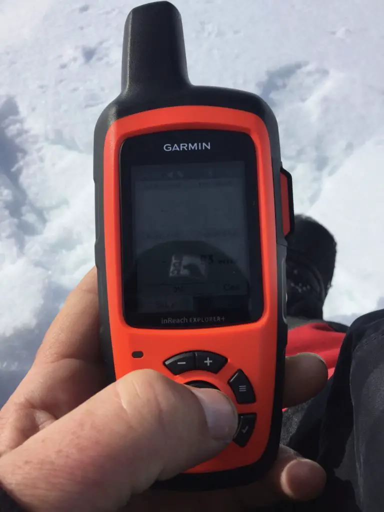
The Garmin InReach is a major step up from the basic handheld GPS device. As well as standard waypoints I’m reporting functions the InReach has limited satellite communication capabilities. Unlike a standard GPS which simply track your position on the planet the InReach has the ability to send text and social media messages. With this functionality comes an obvious subscription charge.
What I like about the InReach
- all-in-one messaging and GPS functionality
- it’s incredibly rugged
- it had built in SOS functionality.
Garmin InReach Quick Review
Originally named Delorme, a mapping company with over 40 years of experience, the InReach brand was bought out by Garmin in 2015. The display on the InReach is a little more complex than that of the eTrex 10 due to the many available features. Also, the device has a basic colour display. I’m not so concerned about these latter points on the InReach as the battery life is impressive.
Like most other modern navigation devices, the InReach can be connected to a laptop in order to upload and download data files. The InReach will accept the standard .gpx file format.
Unlike the eTrex 10 the InReach can be connected to a smartphone via an app. Once connected you can plot out route waypoints on your smartphone. In addition, you can also send texts and social media messages via your phone and over the Iridium satellite network. This is a real saving grace as trying to use the InReach’s joystick to type out your messages is incredibly tedious.
The InReach comes in 2 models: The Explorer+ and the SE+. The Explorer Plus gives you the option of downloading full-colour topographical maps. This can be useful if the GPS functionality fails as you can use the maps to track your roots via landmarks and reference points.
There are a number of subscription options for the Iridium network and those are shown below.
Image here
Unlike the etrex 10, the InReach has a rechargeable internal battery.
Garmin InReach Physical Characteristics
Garmin InReach weighs about 7.5 ounces or 212 grams. It’s a little larger than the eTrex – the dimensions are 6.5 inches by 2.7 inches by 1.5 inches.
The battery life on the InReach is a massive 100 hours, and that’s when you have the tracking interval set every 10 minutes. From personal experience, I know that the device will charge from a solar panel – a full charge takes several hours. If you’re going to be using the InReach on a regular basis I recommend rigging your solar panels to charge up your power supply units while you’re on the move.
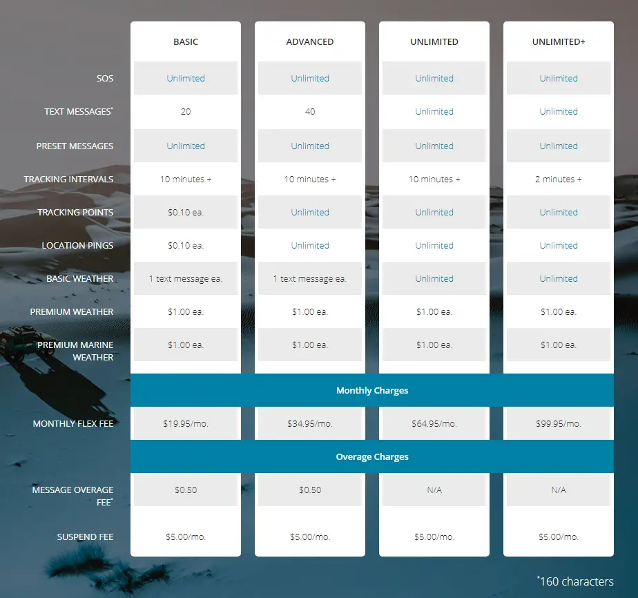
The 2-way messaging feature on the InReach is one thing I really like. The ability to be able to send SMS format messages to friends and family is a great way of keeping in touch and letting people know I am safe. See the image above for subscription plan prices.
The display size on the device is 1.4 by 1.9 inches. this is a huge step up from the dome devices which were considerably smaller and difficult to read.
The InReach has a maximum 200 waypoint limit per route.
The InReach can be connected to a laptop via a data cable to upload and download routes. In addition, Garmin has created an app that lets you control the InReach from your smartphone. You can also load this app onto devices such as an iPod touch or an iPad.
Smartwatches as GPS Devices for Hiking
I know the use of smartwatches-based GPS devices is a slightly contentious issue for some people. But when it comes to simplicity and portability, I find that nothing can beat a smartwatch. In 2016 I took the Microsoft Band 2 to the North Pole and it performed way beyond my expectations. Sadly, my band 2 broke some time ago. Microsoft has discontinued devices I’m getting hold of a new one is hard.
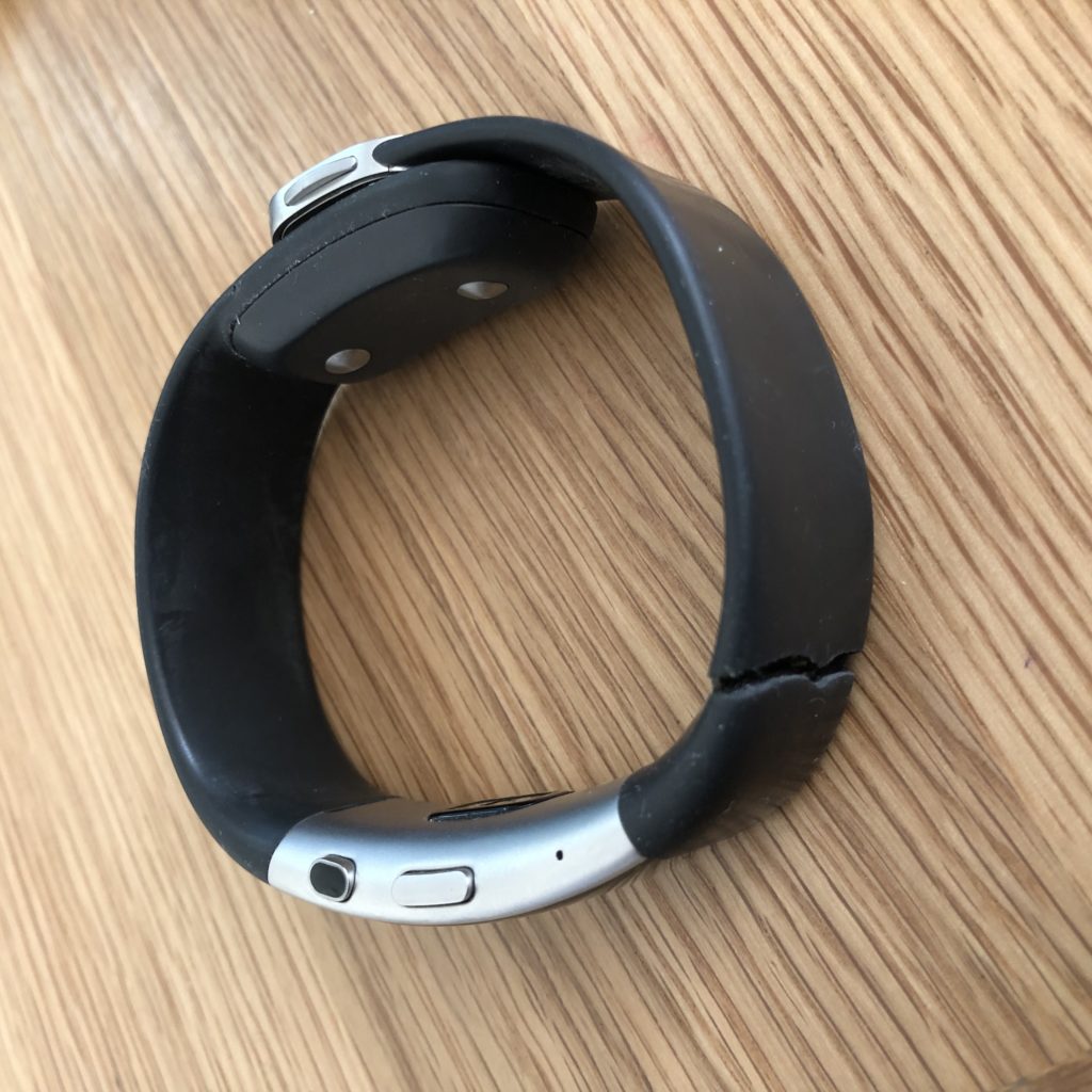
More recently – and only due to my Band 2 breaking – I’ve moved over to a Garmin Vivosmart HR+. As devices go it’s not true GPS as it needs to be coupled with an app in order to be able to track your location. That’s not a major issue for me as on every journey I go on I take a smartphone with me.
Why I Liked Using The Microsoft Band 2 as a GPS
- Incredibly lightweight -you’ll never even know you’re wearing it until you need to use it
- Fairly long battery life – Band 2 worked for two days before requiring a charge
- Charging time is incredibly quick, even when using solar devices
Microsoft Band 2 Quick Review
Unlike the InReach, the Band 2 passively tracks your routes as it’s always on. As an added bonus for anyone who takes his fitness seriously, the device will measure your heart rate constantly.
The Microsoft Band 2 is connected to your smartphone via the MS Health app (like the Band 2 watch, the app is now discontinued). The app was available for iPhone, Android and Windows devices. On a positive note, numerous other apps work with the Band and Band 2 – Strava being one of the better options.
When I went to the North Pole, I worked with Microsoft to develop a bespoke application which tracked various health points as I skied. Some of the technology was later integrated into there are other health-related software created by Microsoft.
If you intend to use this more as a sports device, you can set personalised goals as well as downloading preconfigured training plans.
The display is incredibly simple and shows only key information. To view GPS tracking features, you will have to use a smartphone or similar device with an app installed.
Routes can be added, but only via an app. I never used this feature as my Band 2 for GPS tracking only.
Microsoft Band 2 Physical Characteristics
The Band 2 is incredibly light – a mere 60g, which makes it the lightest of all the GPS devices I’ve spoken about today. There are smaller devices out there, but I have a real love of the Band 2’s design.
The screen size is 12.8mm x 32mm (320 x 128 pixels) which may seem small for anyone used to using a regular GPS. But we are using the watch for GPS tracking only.
For me, the styling of the watch was important. I had used the Band 1 and, in all honesty, it was uncomfortable to wear. The version 2 was a stellar leap in comfort and functionality. It’s a real shame Microsoft didn’t continue building more of these watches.
Before I wrap up this post, I want to cover an oft-asked question…
Why is GPS free?
GPS is free, and it’s not. That may seem like a confusing answer so I’ll answer as best I can.
The Global Positioning System design concept originated in the 1970s and was intended to be a system available only to the US military. Central to this idea was the ability to allow ships, aircraft, and personnel to track their position, thereby giving them enhanced navigation, and allowing command structures to see exactly where resources were at any point in time.
So the US Department of Defense signed off on the idea and the first GPS satellite went live in February 1978.
In 1983 Korean Air flight 007 was shot down by Soviet air-to-air missiles when it veered off course and flew over Kamchatka. with the loss of all lives on board. There were no survivors. Shortly after this incident, then President Ronald Reagan announced GPS would be made available to civilians so that such future losses were preventable.
Do you have to pay for GPS?
No, but you will need to buy a receiver in order to get access to the network and use the tracking system. And this is where it can get pricey.
Most handheld GPS units come with a huge range of features you simply don’t need to be able to navigate well. Top-of-the-range units with colour maps, 3D displays, and in-built satellite communications features will cost you an arm and a leg (for our non-English readers, that means a lot of money). But let’s be clear: you are not paying for access to the GPS network, because it’s free to use. Instead, your hard-earned money is being spent on features that you probably don’t need or will rarely use.
Before we move, I’d like to clear up another common mistake – the difference between GPS and satellite communications.
GPS is a system that allows you to track your location anywhere in the world (but not underground, or in a cave, so don’t go there). Satellite communications such as the features found on the Iridium and Thuraya systems allow subscribers to place calls and send short text messages and emails over private satellite networks. And this can get expensive!
Is There Really A Best GPS for Hiking?
No. If you search the web for the best hiking GPS, you will end up going down a maze of rabbit holes. Pretty much every portable GPS device can be used by hikers. Our preferences are a different matter and a full-colour GPS with mapping downloads might be one person’s choice, but not ours.


