Dartmoor Guide: the Best Wild Camping Sites and Walking Routes
Dartmoor wild camping sites and where to find them
Having trouble finding wild camping sites on Dartmoor? We know how you feel – the sites aren’t always obvious and can change on a landowner’s whim, which is why we put this list together. As a boy, I spent many days roaming the wilds of this huge National Park. But many of my camping sites were not ‘approved’, which caused problems when I was caught out.
Although I no longer live in South West England, I do go back from time to time and spend a couple of days hiking across the moorlands (and, in part, my love of this area was the reason for building TrekSumo). One of my recent trips followed a north-to-south route of Dartmoor (more on that later in this post) during which I camped out. And the weather was wild!
So, without further ado, here’s a list of the best places to wild camp, including what I think are some of the most scenic and awe-inspiring sites.
Dartmoor Wild Camping Map
Before we delve into the best spots, here’s the official list of places you can wild camp:
https://www.dartmoor.gov.uk/about-us/about-us-maps/camping-map
As you can see, huge tracts of land are open to hikers wanting to pause overnight without having to pop into a hotel or B&B. But, even in the shaded areas, there are restrictions which we’ll cover shortly.
Dartmoor National Park
First, a quick glance at Dartmoor National Park.
Located in South West England, this National Park covers 368 square miles (954 square kilometres) and, for the most part, is open to the public. As with any of the Parks in the UK, there are some restrictions to access as much of the undulating terrain is under private ownership. This doesn’t mean you can’t hike, but you’ll need to watch out for signage telling you about any limitations placed on routes.
The most common complaint from landowners is the lack of respect hikers have for livestock and we encourage you to follow the rules. The most obvious of these is protecting livestock. If you’re hiking, or walking, with a dog, keep it under control. Farmers have the right to shoot dogs bothering cattle, sheep, horses, etc.
Which map shows the camping sites?
The easiest way to work out where you can wild camp is to use the link above. But for all you hardened hikers and campers who prefer to use paper maps (and plan to go ‘off-piste’), you’ll need the following:
- OS Map OL 28
This map will provide you with all in the information needed to plan your stops.
Note: I prefer to put up my tent in less visited areas. The following locations are perfect for anyone wanting a little seclusion in their journey.
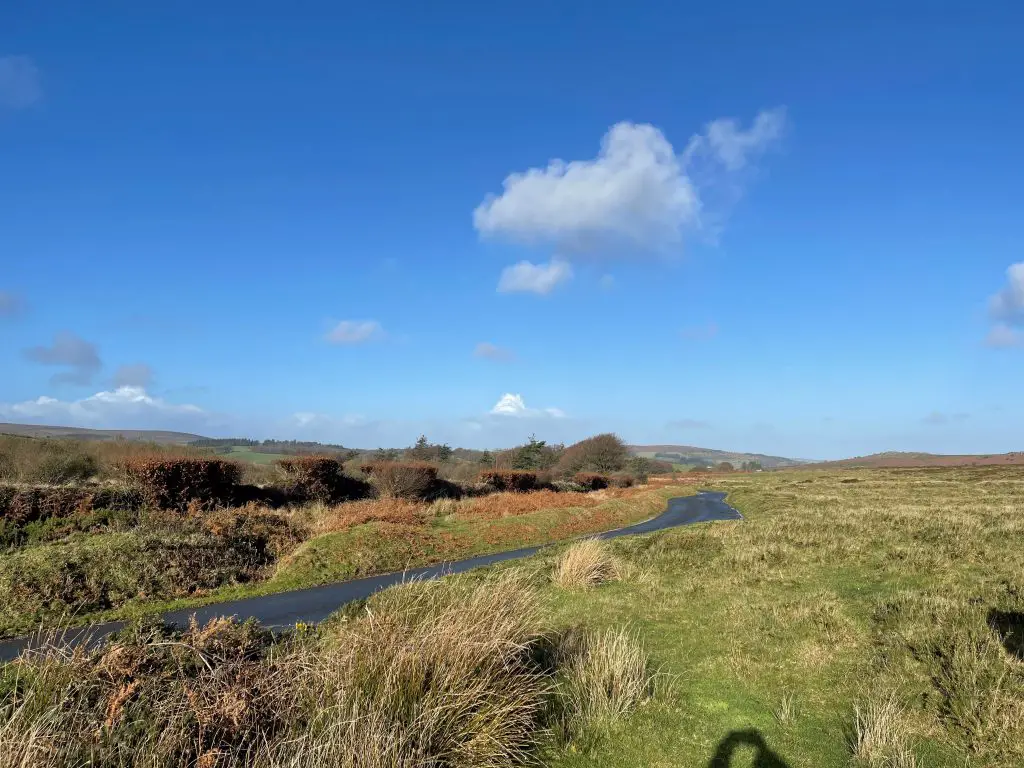
The best wild camping sites on Dartmoor
Armed with your map and a plan for a long weekend of walking the hills, it’s time to look at what we consider some of the very sites wild campers will ever have the delight to sleep in. Each location shows the nearest car park for those of you intending to set off from, or at the end of your hike, from the comfort of a vehicle.
Bellever Forest campsite
Grid reference: SX 656 770
Wrapped around Bellever Tor, Bellever Forest is one of the most iconic and most visited sites on Dartmoor. The origins of the modern forest date back to 1931 when the land was bought by the Forestry Commission. After purchase, the Commission started the process of planting the trees that now cover this large tract of land. I have to admit it’s one of my favourite destinations, even when I’m not hiking.
Located not far from the village of Postbridge, Bellever caters to hikers and day walkers alike. There’s a convenient car park (pay and display) as well as toilets. Being close to habitation makes it easy to dip into local accommodation should you feel the need to get away from your tent for the night.
Part of 230 square mile Parish of Dartmoor Forest, the woodland is a mix of dense and patchwork green giving hikers plenty of places to secret themselves away from prying eyes (and allowing adherence to the camping code). What’s more, much of the abundant wildlife roaming the area can be seen early morning and evening if you’re not zipped up inside your sleeping bag.
When it comes to hiking and walking, you’re spoilt for choice – many footpaths crisscross this area and, whilst it can be easy to take the wrong path – and you have plenty of options for exploring Bellever.
But the forest isn’t the only site I recommend visiting – hike to the top of the imposing Bellever Tor and pause awhile as you take in breathtaking views out across the moorland. Trust me, it’s worth the walk.
Nearest car park: Bellever car park, OS grid reference SX 656 770
Riddon Ridge
Grid reference: SX 666 763
Not far from Bellever, located on the high ground above the forest, is Riddon Ridge, another great location for an overnight stop. Although you could say both locations fall under the same natural grouping, that would be a travesty!
At 380 metres high, the ridge offers views out over Bellever and large sections of the moorlands.
The western route up Riddon Ridge from Bellever is fairly steep in places and hikers wanting a more sedate walk to the top should consider the eastern approach which has a much shallower incline. Once at the summit, there is ample space to pitch camp where, given the isolated nature of this place, your tent will be difficult to see from any nearby dwellings.
Around 2km to the west is Bellever Tor, and 5km to the northwest is Higher White Tor. Both hills are significantly higher than Riddon Ridge which makes them excellent reference points and easy to navigate to.
Nearest car park: Bellever car park, OS grid reference SX 656 770
Merrivale
Grid reference: SX 555 749
Not an official wild camping site, Merrivale has so much to offer, and I recommend you use the official site at Smith Hill. That said, I ‘may’ have overnighted near Merrivale and, as a considerate camper, I left no sign of my passing. The choice is yours…
For the historian, amateur or seasoned alike, there are the standing stones and remnants of a settlement dating back as far as 2,500 BC. Hike out a short way from these prehistoric remnants and you’ll find a series of river valleys (careful: these can be deep and fast-flowing after heavy rain) to explore.
If you’re looking for more history, or simply something scenic, there’s a disused quarry (I find these fascinating… I know, I know) and scarred relics leftover from the medieval period.
One factor to bear in mind when camping here – Merrivale settlement is close to one of the main roads across Dartmoor and the safest bet is to pitch a tent just beyond the site, in some dead ground.
Fancy a night of carefree dining (aka not eating freeze-dried food that hasn’t quite absorbed enough water to make it less crunchy)? Then definitely pay a visit to the Eversfield Organic Dartmoor Inn, a 17th Century Free House sat a short distance from the quarry. The food is excellent.
Nearest car park: Four Winds car park, OS grid reference SX 560 748
Burrator
Grid reference: SX 559 677
Burrator is an absolute gem and should be high on your list of places to visit, even if you don’t wild camp. Ringed by tors, open moorland and settlements dating back thousands of years, the Nature Reserve at the heart of Burrator is truly stunning. In fact, Burrator is an ideal destination for a day out and a more sedate walk in the countryside.
Venture away from the reservoir and you’ll find two great places, east and west, to pause overnight. In the east is Sheeps Tor, a high spot overlooking the reservoir and the site of an ancient settlement like that at Merrivale. In the west is Yennadon Down, which stands above the village of Dousland. Both sites are edged by Burrator forest providing plenty of places to pitch your tent out of sight.
Nearest car park: Burrator Reservoir car park, OS grid reference SX 548 677
Great Kneeset
Grid reference: SX 589 859
Located in the middle of north Dartmoor, and a short distance from Okehampton Battle Camp, Great Knesset is one of those places where you must pay attention. Out of interest, the Tor’s name appears to be a reference to the many rocky outcrops where you can sit and look out onto the moors, rather than the pain you’ll feel in your knees after climbing the steep flanks!
The north moorland is, to my mind, a more extreme environment with little infrastructure beyond the towns and villages, most of which are some distance away. Additionally, there are no tarmac roads within at least 8km of the hill which means your wild camping options are far broader. Several trails and tracks pass nearby, but they aren’t classed as highways… unless you’re a sheep. Or a hiker.
What does all this mean? You can camp where you like if the range flags aren’t flying!
Climb to the top of Great Knesset and you’ll be rewarded with views out across the entire north moor. And it’s from you’ll be able to map out numerous other locations where you can wild camp.
On a personal note – I love the north of Dartmoor. Rugged, isolated and when the guns aren’t firing, incredibly peaceful. It’s the perfect destination.
Nearest car park: Meldon Reservoir car park, OS grid reference SX 563 917 (about 7km away… I did say this is a remote area)
Considerations and final thoughts
Dartmoor National Park is one of the more natural gems in the British countryside. True, the landscape so many people love and enjoy is the result of deforestation, but that act was carried out long before our time. What we have now is an environment that is unique and beautiful, and we need to keep it that way – for ourselves, and future generations.
With that in mind, here are a few thoughts (including personal bugbears) on how we can preserve this place.
Obey the National Park Authority’s rules!
The NPA exists to protect and promote the UK’s National Parks and the rules they lay down are designed to protect visitors, the environment and livestock. I have to admit that following rules have never been high on my list, but in this case, I’ll defer! If a sign says ‘Out of Bounds’, then take that advice. Hint: there are live firing ranges on Dartmoor, many in the north, and you really don’t want to ignore the big red flags which are flown when soldiers are pouring lead across the hills!
I think that’s a fair warning.
What are the rules?
The rules for any Dartmoor wild camping site are easy to understand:
- You must pitch your tent at least 100 metres away from any road, and it must be in a location where you’re not visible from the roads, or any nearby dwellings;
- No camping on, or near, farmland (be polite – farmers can be your best friend in a time of need), areas of special interest, nature reserves or archaeological sites;
- No open fires (during the summer months Dartmoor is at risk of devastating wildfires that destroy fauna and flora. Some of these blazes have been caused by campers);
- Take your litter home with you (nobody wants to see a badger with its head stuck in a soup can).
Note:Every year, from the 7th August there is a ban of 7 days on wild camping.
Be polite to the locals
I’m a Devon boy and I’ve heard just about every insult that could be levelled at me as a result of my county of birth. And I’ve never been phased. But upset the locals and you might find yourself short of ‘friends’ if you’re ever in need. One group of people you don’t want to get on the wrong side of is farmers as many have been treated with disrespect by groups of people rambling across their land.
Don’t feed the animals
Really, that Dartmoor pony isn’t eyeing your cheese sandwich because he’s hungry – it’s just easy food, which I think most of us would mop up in an instant. Joking aside, the wildlife of the moors has adapted to find nourishment in places we flabby humans wouldn’t even consider. The constant feeding of animals attracts them to car parks where they are at risk of being hit by vehicles. In addition, a pony’s digestive system isn’t designed to handle leftover curry!
Hiking etiquette isn’t a quaint idea
It’s very real. At its most basic, hiking etiquette means ‘don’t leave your rubbish lying around’. Tin cans, and food wrappers, attract animals which then attempt to scrape food scrapes from said offending item. It’s not nice seeing a wild animal with its muzzle stuck in a food can. What’s more, seeing discarded plastic wrappers being blown over the hills, and through the valleys, kills the vibe!
The best places to walk on Dartmoor
No guide to Dartmoor would be complete without a list of the best places to walk.
North to South crossing (our top recommendation)
A north to south crossing of Dartmoor is a serious undertaking, especially if you want to complete the journey in a full day, which I attempted. I recommend starting in Belstone, near Okehampton as there is a place you can stay overnight to prepare your kit and get a good rest/breakfast before the day ahead – the Tors Inn. The accommodation is adequate, and the cooked breakfast is cracking!
My endpoint for the crossing was Ivybridge on the far side of the moors, where you can pick up public transport that will take you back to Belstone.
Princetown Railway and King Tor
The Princetown Railway mountain biking routes offer a choice of long or short family-friendly routes following the former railway and minor roads. The short route is 6 miles/10 km and circles Kings Tor whereas the longer route of 19 miles / 30 km heads south along the former rail track towards Burrator Reservoir, set amidst stunning scenery, and returns along the same route.
Spoiler alert: this route is a long gravel path, which may be a bit monotonous for some. When you reach King’s Tor, choose between sticking to the railway track or opting for a short, easy uphill walk on the grass. What I noticed on my first climb of King’s Tor is its impressive size, larger than expected from a lower perspective and more than enough to get my heart and lungs into that warm and fuzzy state.
Roll off the top of King’s Tor, loop back, and then decide whether to stay on the railway path towards Princetown or take the grassier, but not necessarily easier, route leading to an unexpected find – Foggintor Quarry. Trust me when I say you HAVE to visit this relic of Dartmoor’s history; being both beautiful and in seclusion, it’s one of the highlights you can’t help but pause and admire.
One point to note: although the route is simple, getting to the locations can be problematic as you rely on public transport which is often cancelled.
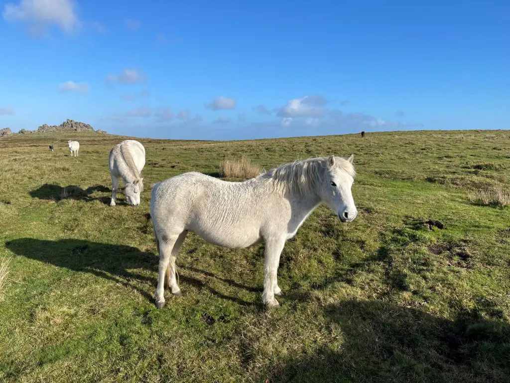
Before we move on, there’s a lingering question (the same one my now 19-year-old daughter asks every time we head up onto the moors) – will we see a Dartmoor Pony? Sorry to say, it’s not guaranteed so here’s a photo to put a smile on your pony-loving face…

Warren House Inn from Widecombe
The historic Warren House Inn is both the start and end of this route. I’ve been told, the Inn’s open fire has been burning continuously burning fire since 1845, but I’m doubtful. The sheer cost of fuel makes this unlikely… yeah, I’m a sceptic!

This trail is suitable for walkers of most abilities or cyclists. Its adaptable variations cater to different preferences, adjusting difficulty based on mood, age, fitness, and weather conditions. Although buses are available for accessibility, there’s currently no accommodation for bikes.
Primarily off-road, the trail follows unsurfaced bridleways, giving you a good mix of rough terrain and occasional mud or standing water. The main route is around 5 miles (8km) distance, which I covered in 2 hours (I was moving pretty fast). For some, this might seem like a long time for a short distance, but the route can be slow going in places as there is often deep, cloying mud and lying water.
Belstone Ridge and Cosdon Hill
Cosdon Hill, a sprawling moorland near the northern border of Dartmoor National Park, offers various walks to its summit and beacon, starting from the village of Belstone. Despite the hill’s size, the ascent is manageable and suitable for families with young children.
As I mentioned at the start of this post, please take time to pause in Belstone. It’s spectacularly old inhabitation with truly beautiful buildings and amazing views.
Head east along the northern flank of Cosdon Hill, avoiding the boggy southeastern route to the summit. After about a kilometre, grass paths lead to Cosdon Beacon, marked by a distinctive pile of rocks and a trig point, offering expansive views like this…

Continue south to the Little Hound Tor area, visiting White Moor Stone Circle and White Moor Stone. Follow the grass path northwest to a ford below White Hill. From here, choose between staying on the western flank via Queenie Meads and Lady Brook or crossing the River Taw Ford for a scenic route along Taw Plain back to Belstone, noting its potential impassability after wet weather.
Begin at the car park near Belstone’s main entrance by Brenamoor Common. Pass through the village, reaching Belstone Great Green, with the village church and pub to your right. Cosdon Hill lies ahead, and Belstone Cleave descends to the left. Cross the footbridge over the River Taw and ascend to the moorland, diverging from the Tarka Trail.
Once atop Cosdon Hill, you can either retrace your steps or explore the varied routes for a different perspective on the stunning surroundings.
The Dartmoor Way
The Dartmoor Way, a well-marked 108-mile (173km) circular route encircling the moors, traverses quiet footpaths, bridleways, and lesser-used byways, meandering through charming towns and villages. These settlements provide diverse options for food and accommodation and there are plenty of places for wild camping.
This scenic route unfolds across wooded valleys, glistening streams cascading from the moor, and historic drove-roads and bridleways frequented by generations of farmers and travelers. It has an appeal that endures through all seasons, from the vibrant hues of Spring to the splendours of high Summer and the rich colours of Autumn, culminating in the stark beauty of Winter.
The High Moor Link extends from Tavistock to Buckfast, facilitating smaller circles around the Northern or Southern Moors. Intersecting with the Two-Moors Way long-distance footpath, the Dartmoor Way presents various route possibilities.
Whether for a day trip, a weekend getaway, or a comprehensive 10-day holiday, the Dartmoor Way beckons with its array of possibilities for a refreshing break.
Lydford Gorge
The full Lydford Gorge walk spans approximately three miles, requiring up to two hours to complete. Caution is advised, as the terrain features treacherous sections with steep inclines and narrow, occasionally slippery paths. Essential walking boots are recommended. For a more accessible stroll with breathtaking gorge views, opt for the winding upper path.
Choosing the upper path leads to a fork, where you can descend gently to the riverside or take a quicker route via 220 steep steps. Both paths converge at the bottom of the gorge, where the River Lyd crashes and flows in a spectacular manner.

Following the riverside path in the gorge unveils small waterfalls, leading to the White Lady waterfall, named after a local legend of a ghostly lady occasionally spotted in a long white gown.
The rushing streams create a captivating spectacle, with thundering water cascading into pools and swirling like an avalanche. The noise is so intense that conversations become a challenge over the torrent.
Wooden walkways in parts of the gorge route elevate you to higher viewpoints, offering a unique perspective of the swirling water from above.
Explore the most dramatic section of the River Lyd on this challenging circular trail. It’s an exhilarating trail through ancient woodland and the rocky gorge to the towering Whitelady Waterfall and the roaring Devil’s Cauldron.
Two Moors Way
Stretching just over 100 miles/160km from Ivybridge in the south to Lynmouth in the north, this renowned path connects Dartmoor and Exmoor National Parks. Showcasing diverse scenery, the trail encompasses a stretch of moorland wilderness, the picturesque River Dart Valley, unspoiled central Devon, and Exmoor’s deep wooded valleys with panoramic moorland views.

Walking the route is generally easy, featuring one or two challenging sections. It is well-marked, except for the open moorland parts that demand navigational skills. Public transport is accessible in towns and villages along the route, facilitating flexible hikes with bus connections at Ivybridge, Bennett’s Cross, Chagford, Drewsteignton, Morchard Road, Morchard Bishop, Witheridge, and Lynmouth. Morchard Road is part of the Tarka Railway Line between Exeter and Barnstaple.
Facilities are available in Ivybridge, Widecombe, Chagford, Simonsbath, and Lynmouth. The terrain is mostly easy, with a few challenging stretches, and a portion of open moorland walking requiring navigational skills.
Wrapping it all up
You’re spoilt for choice! The sheer number of wild camping sites on Dartmoor make this National Park and must-visit destination for anyone looking to get away from the crowds often found in the bigger, more visited Parks. Whilst you’re here, why not check out the growing list of hiking and walking routes in England and the wider UK.


